The Time It Takes to Drive the Entire Length of Maine’s Route 1
The Ultimate Road Trip: How Long It Takes to Drive Maine’s Route 1
Who doesn’t love a scenic road trip?
You don’t even have to leave Maine to enjoy a fun and relaxing drive. The state offers a variety of beautiful routes, including coastal highways, picturesque city streets, and charming village roads. For such a peaceful state, Maine is packed with incredible scenic drives that make for the perfect road trip.
Maine is also home to the most famous road in the entire country, U.S. Route 1. The highway stretches over 2,300 miles, from Fort Kent all the way down to Key West. In fact, it’s quite a tourist attraction on the small island. I probably have a picture or two somewhere on my phone from when I visited a few years ago.
Parts of Maine’s Route 1 are simply stunning, mainly because it runs relatively close to the coast. It also passes through numerous beach towns and attractions. However, only someone with WAY too much time on their hands would actually use Route 1 for a long road trip here—it’s just not efficient. That’s why God created interstates. But interstates aren’t nearly as fun.
How Long Does It Take to Drive the Entire Length of U.S. Route 1 in Maine?
You know what’s fun? Trying to figure out how long it would actually take to drive Route 1 from Kittery all the way to Fort Kent.
Sadly, I don’t have the free time to make the drive and see how long it would take, so we’ll be relying on Google Maps estimations. Let’s start with the quickest route between Kittery and Fort Kent. This will give us an idea of how long it should take if you follow the most direct path.
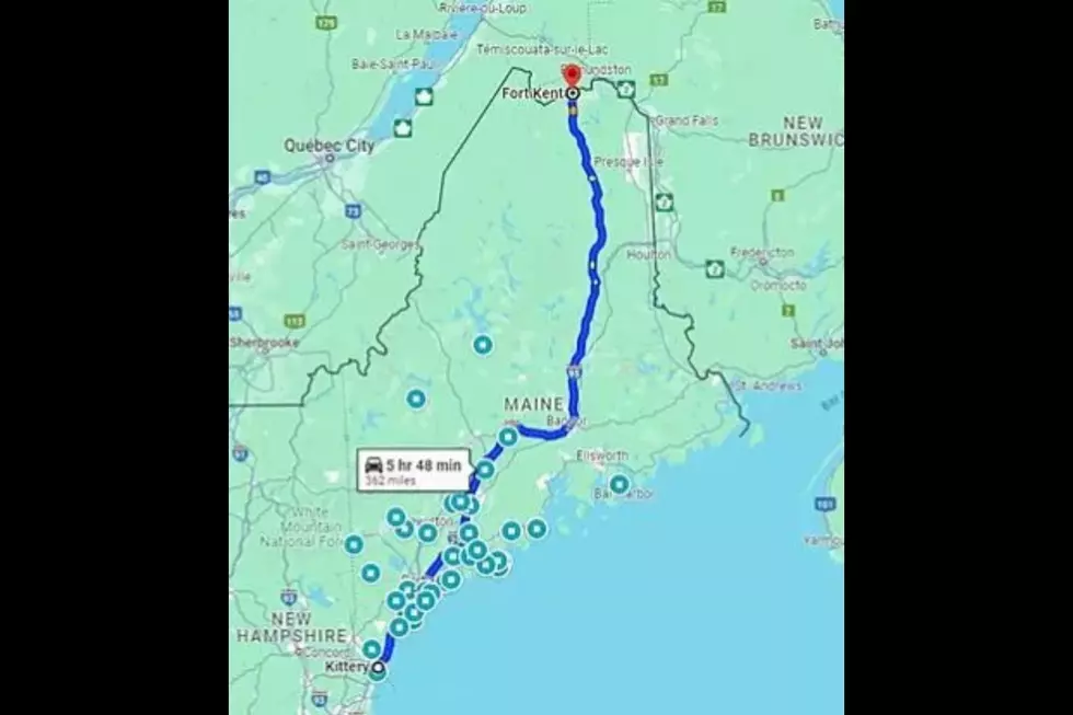
Time: 5 hours 48 minutes
Miles: 362
That's not too bad. I mean, it's quite a stretch, but certainly doable. It's like driving from Portland to New York City, but I think Fort Kent might be a little smaller than NYC.
Now, let's take a look at how long the drive would be if we eliminated the use of interstates.

Time: 8 hours 25 minutes
Miles: 382
Now we're talking. This would be a solid workday's length of driving, just so you can avoid paying a few tolls. I'm sure some Mainers have done this over the years. I mean, we are a frugal bunch.
On to the fun part. How long would it take if you drove from Kittery to Fort Kent while only using Route 1?

Time: 12 hours 20 minutes
Miles: 526
That is quite the long haul. It's roughly the same estimated time as it would take you to drive from Portland to Columbus, Ohio. Go look at a map. Portland and Columbus are not close.
The drive would most likely be even longer, considering lights, traffic, road conditions, construction, roadside attractions, and other factors. I bet the actual number is closer to 15 hours, which is absolutely wild.
So, who is ready to try it out? I'm sure this hasn't scared you away from this challenge. I have to be honest; I might have to try this later in the year. I kind of want to do it during prime tourist season so I can experience true pain.
Happy travels.
40 Maine Restaurants That are Worth a Long Drive to Get to
Gallery Credit: Chris Sedenka
Totally ’80s: The Pictures That Take You Back
Gallery Credit: Stephen Lenz
More From WQCB Brewer Maine